Friday, July 16, 2010

Glacier National Park


Park entrance


Marsha's passenger view of the shoulder of the road. Note the rear view mirror. I told you she refused to get out ot the car.


Marsha's passenger view of the road taken from the passenger seat.


Logan Pass


Mountain goats along the way. Sasha and I wanted to go say hi, but Larry just kept on driving.


A tour bus driving along a section of the highway known as the "Weeping Wall."


One of the views along the way with Larry taking a picture of something


Date: Friday, July 26th
Day: 63
RV Miles: 5,581
Location: West Glacier, Montana
Elevation: 3,718

Well Larry finally got us out of Spokane and on to Missoula, Montana. On Thursday, we drove up the West side of the Rockies to West Glacier, Montana. Today, I took Larry and Sasha on patrol about 6:30 (Sasha has reverted to waking Larry up at dawn every day – 5:30AM). At 7AM while on patrol Larry called Marsha on his cell phone to roll her sorry butt out of bed and get breakfast on. By 8:30, we had the car loaded up and set off for the park.

The primary attraction at the park is the “Going-to-the-sun Highway” up across Logan pass and the continental divide. Larry has never been on this highway but has spoken to others who have described it as one of the gnarliest mountain highways around. Based on this, Larry did not give Marsha the option of driving and he drove. He told me he did this because he figured it would freak Marsha out. Seems he was right.

The ascent up to Logan’s Pass was along a very narrow, steep and twisty road known as the “Going-to-the-sun Highway”. There was no shoulder and in places, there was no guardrail, but there was always a huge vertical drop off. Seemed like the mountains sides here were nothing more than near-vertical cliffs that someone managed to scratch a road into. The scenery was, as expected, incredible. Normally, this would have created a situation where Marsha would want to get out and take pictures every two minutes. Not on this trip: She refused to get out of the car – she wanted more room to walk around and less drop-off to worry about.

Larry was initially planning to go to Logan’s Pass, then turn around, and head back. To give you an idea how spooked Marsha was of the highway, she convinced him to keep going to the East side of the Park. She did not want to go back down that road. The eastbound descent to East Glacier was a lot easier than the ascent to Logan’s Pass.

Once Marsha decided to keep going, the only way home was to drive about 90 miles back to West Glacier along US Route 2 (it was 30 miles if they would have just gone back down the mountain the way they came).

Along the way, we went through, East Glacier, an old railroad town build around a grand lodge also built by the railroad for tourists about 1900. The engineering and structure of the lodge fascinated Larry; Marsha wanted to take pictures of the flowers out front. We stopped there for lunch. A chattering Magpie in the tree above the picnic table fascinated me and Sasha found a dead bird that she wanted to play with.

Tomorrow, we drive back to Missoula for the night and then it is on to Yellowstone. Larry discovered that all of the campgrounds in and around Yellowstone were booked solid, but he did find one spot in a campground in Gardiner, Montana just about 5 miles north of the north entrance to Yellowstone.

Tuesday, July 13, 2010

Victoria and Mt. Rainier


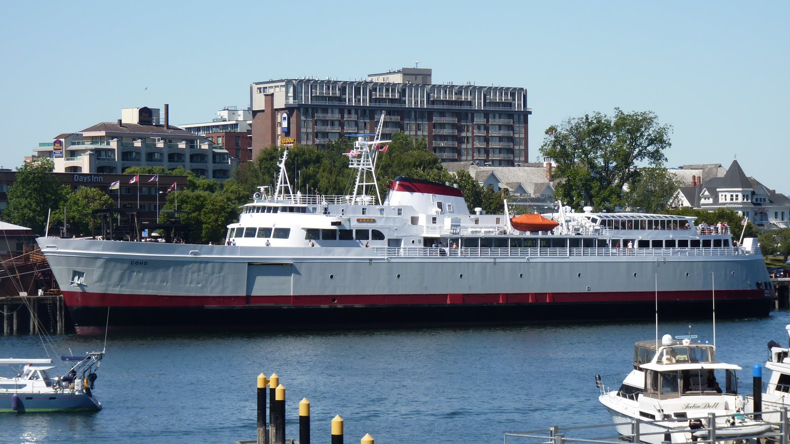
The Port Angeles to Victoria Ferry - The Coho


Marsha watching the Washington Shore getting farther away


Larry enjoying the voyage


Marsha on the grand staircase in "The Castle"


Wierdness in Victoria - Darth Vader playing a violin?

Date: Thursday July 8th
Day: 55
RV Miles: 4,763
Location: 13 Miles Southwest of Port Angeles
Elevation: 158

Even though this blog describes the events of July 8th, it is being written in Spokane, Washington on July13th after a two day medical hold on the vacation. It seems that Sasha and I had a day from hell and then Larry and Marsha landed us in the campground from hell. Larry and I both wound up laid up.
Read on and I will explain.

On Thursday Larry and Marsha set off on the Ferry Coho to visit Victoria, British Columbia for a few hours. Larry is an old hand at this big boat on blue water stuff but it was all new for Marsha, the ship rock’n and roll’n and the ship blasting its horn tickled Marsha to death. According to Larry she giggled her way across the straight from Port Angeles to Victoria. Once there they spent five hours walking the town and going to two tourist venues, “the Castle” and a place called “Miniature World.”

Marsha enjoyed "The Castle" the most. The grand staircase was four stories high and was solid wood paneling all the way up. She must have taken a hundred pictures of all of the antique furniture.

While in Victoria, they dropped Sasha and me off at a doggie day-care. So far this has been a pretty good plan and Sasha and I have generally enjoyed getting to know other dogs. This place, however, turned out to be different. The place looked nice but Sasha and I had to stay in crates for over 10 hours, something Larry and Marsha didn’t figure out until they picked us up. For Sasha and I, it was the day from hell, and then it seems 48 hours later I got sick, probably from a bug I picked up there.

Friday July 9th we drove south to be near Mt. Rainier our next destination. It seems there are many lakes near Mt. Rainer with some pretty good fishing. It being Friday with good weather predicted for the weekend, all of the campgrounds near Mt. Rainier were full except one in Eatonville. Hereafter referred to as the campground from hell.

The Campground from Hell was on a little dinky lake that had every inch of shoreline taken up with resorts or marinas of some kind. The RV parking was extremely cramped with only 14 feet between RV sites (our RV is 10 feet wide if you include the mirrors). Most of the RV in the Campground from Hell were there permanently and some of them were owned by the campground and rented out on a daily or weekly basis. We had to have water run to our camper though a regular garden hose, and the electricity service was barely enough to run the air conditioner (it was over 90 degrees in Eatonville). But ,I think the thing that characterizes the campground more than anything was the fight.

A fight ensued between a husband and wife (with 3 kids) and the camp management in an adjacent RV site. They had rented a 20 foot camper, hadn’t paid the rent and were evicted forcibly the day before. They returned and move right back in and . . . well a fight broke out with police and everything. It was like watching the TV series “Cops”


Entrance to National Park on a crowded Saturday


Mt. Rainier from 25 miles away


Problem: The closer you get to the mountain the harder it is to get a picture of it.


Marsha and the Mountain (Note she has revived the floppy hat - no wind)


Larry taking the previous picture


Well we got to Mt. Rainier and then got the heck out of Eatonville on Sunday the 11th. Getting out of Eatonville is how Larry hurt his back. Because of the way we had to park in the Campground from Hell, we had to unhook the car tow dolly and put it in a spot that had real spongy ground. When Larry went to swing the tongue around so he could hook it back up to the RV, the wheels had sunk into the soft ground. This made it really hard to move the tow dolly. Larry got it moved but threw his back out in the process.

By the time we go to Spokane, Larry’s back was killing him and it was clearly obvious that I was way under the weather. As soon as we got to Spokane, Larry and Marsha they took me to the doctor who gave me some antibiotics and a special diet. The next day, Monday, Larry and I cratered. Today we are feeling better and tomorrow, (Wednesday) we will move on to our next destination, Glacier National Park. We have two days of traveling to get there, so it will be Friday before we visit the park.

Tuesday, July 6, 2010

Cape Flattery and La Push


The trail to Cape Flattery. This is about the only level spot in the trail.


This is South of the Cape by about a hundred yards and it gives you an idea how rugged the coast is. The viewpoint is about 150 feet above the ocean.


Tatoosh Island and the Cape Flattery Lighthouse. The island is the most North West point in the lower 48 states.


A close-up of the Cape Flattery Lighthouse


La Push Beach 1


Larry and Sasha at Beach 1

Date: Monday and Tuesday, July 5th and 6th
Day: 52 and 53
RV Miles: 4,713
Location: Forks, WA
Elevation: 299

The rain and celebrating on Sunday must have wore Larry and Marsha out since they took it pretty easy on Monday and Tuesday.

On Monday, we all piled in the car and headed for Cape Flattery the most North and West point on the mainland in the lower 48 states. Tatoosh Island and he Cape Flattery lighthouse is the most North and West point in the US not on the mainland.

I think the humans thought this would be a simple 30-mile trip. Wrong. The 30-mile drive took about 90 minutes and got them to within a half mile of Cape Flattery. I'm getting the impression that up here they measure all distances "as the eagle flies." The drive was scenic along the rugged and rocky southern coast of the Strait of Juan De Fuca. The last ten miles or so were really gnarly as we headed away from the coast on a not-very-major highway where they didn't make any effort whatsoever to make it straight or level. Then the last half mile was a killer.

You had to hike it and it was downhill to the cape, which meant it was all uphill back to the car. Larry did pretty well but Marsha was wasted. Larry told me that the ground off the trail was like walking on a sponge; very soft, mushy and squishy. He said you could even hear the squish. I guess this is to be expected in these parts with all of the rain they get here. Larry said he couldn't get a picture of the Cape because when they got there they were on top of a big rock and the only picture he could take were down or out to sea. Said he had to settle for pictures of Tatoosh Island.

Not to be outdone, the weatherman pulled another beautiful day out of his hat for Tuesday; Sunny with a high of about 85. The local weather forecast was published with heat wave warnings and cautions about over exertion in such hot conditions. Today may have been a record hot day here in Forks.

Sasha wanted to complete the Twilight tour of the area so Larry and Marsha agreed to go to La Push, home of Jacob the werewolf and visit Beach 1 where he and Bella had many nice talks. From Forks the beach was only 15 miles and the temperature dropped form 77 to 54 by the time we reached the beach. The ocean has that much of an effect on the temperature here. It is truely amazing.

The beach is on an Indian reservation and they have kept it very natural and do not clear the driftwood from the beach. Marsha said that this makes it is very difficult and dangerous for elderly humans to cross the driftwood to actually get to the waters-edge. Sasha and I thought it realy looked interesting and there had to be all kinds of interesting stuff down there but they wouldn't let us go explore. DRATS!

Tomorrow Larry tells me we are headed to Port Angeles, on the North Shore of the Olympic Peninsula to get into position for a one day excursion to Canada by Ferry.

Old Fashion Forks Fourth


The crowd gathers on Main Street in Forks waiting for the parade


Sasha's favorite float


The Irrigation Festival (?) Float


Lots of vintage cars


A logger and five very cold ladies


"Hey Toto, I think we're in logging country."


Sign on the Forks Community Hospital Float


The Forks Float


Even Elvis showed up


Just watching the parade


Sasha and I shaking it off


"I'm miseragle"


Larry and Marsha at the derby. Can you believe it, they are smiling.


Larry and Marsha weren't the only ones to show up for the demolition derby.


I don't get it. Stand in the rain and watch people destroy cars. Humans!


Date: Friday, July 4th
Day: 51
RV Miles: 4,713
Location: Forks, WA
Elevation: 299

Humans are so unpredictable; I’ll never figure them out. Anywhere else in the United States if you threw a 4th of July bash and it rained no one would show up. Here in Forks, they throw a 4th of July bash, it rains and everyone from 50 miles around shows up. While watching the parade, I asked a passing bloodhound why this was. He just said, “If you get scared off by rain here in Forks, you would never go outside. Some days it is cloudy. Some days it rains. What’s the difference?”

Well that explains it for the people who live around here who seem to come from rugged and hearty logger type stock; not so for Larry and Marsha. Back in Indy if it rained they would never go to a parade. Well it rained today, they had a parade and they went and watched it – and they took Sasha and me along. For once, Sasha and I agree, we would have been happier and much drier back in the camper.

Rain or shine, the 4th of July Parade here in Forks is the biggest goings on they have all year and it is quite impressive at that. The town is a mile long end to end. At parade walking speed I have taken Larry on patrol from one end of town to the other and it only takes 20 minutes. The parade lasted an hour and 15 minutes making it about three miles long and the parade route (there is only one route through Forks) was lined with humans two and three deep. The population of this town is about 3,900 not counting dogs, vampires and werewolves and I would say they had at least twice that number show up. Who’d of thunk it?

After things got started I got into the spirit of the thing cause they had some really interesting stuff like vintage cars, logging trucks, pretty (but very cold) girl laden floats and stuff. Sasha was pretty unhappy the entire time, except when the horses went by and she about blew a gasket when the Twilight float passed.

The end of the parade was not the end of the day by any means. After the parade the town threw a salmon Bake and demolition derby. The frog jumping contest was yesterday and we missed it -- Be still my heart. At this point I had a man-to-man talk with Larry and he agreed to take Sasha and me back to the camper and dry us off and leave us there. You see us dogs got enough sense to come in out of the rain.

Who knows what is going to happen tomorrow here in Forks.

Monday, July 5, 2010

The Olympic Coast and Rainforests


Ruby Beach From the Visitors Parking Lot


Ruby Beach Overlook


"Beach 4"


"Awesome, surf's up dude. Let me get my boogie board and we can like hang twenty."


"I'm having like so much fun I don't know which way to run next."


Larry at "Big Cedar"


Marsha at "Big Cedar" peeking through the hole in the trunk.


A rain forest telephone booth.


Date: Friday, July 3rd
Day: 50
RV Miles: 4,713
Location: Forks, WA
Elevation: 299

Today was an easy day – about a 60-mile trip down the coast. The trip was not as scenic as yesterday, but the scenery is still quite breathtaking. There is about a 13 or 14 mile section of the coast that forms a continuous natural beach right along highway 101 (costal highway).

The beaches are really exciting for Sasha and I. There are so many smells and sounds to deal with and then there are the birds and the breeze constantly bringing new smells to your nose. I thought Sasha was going to have a nervous breakdown she kept trying to run in 40 directions at once. I was disappointed though because Larry and Marsha wouldn't let Sasha or I anywhere near the water. I can understand keeping Sasha dry but not a low-maintenance dog like me.

This area has the most rain of anyplace in the continental US and it creates forests that are so dense and lush that there had to be some claim to the world’s biggest trees. On the way back, there were turnoffs to two huge cedar trees and one huge spruce tree. Larry thought that after the redwoods and sequoias anything else would be anti-climatic. He was wrong. They were not as big as other trees we had seen but they were Monarchs in their own right.

The last stop on the way home was, of all things, a rain forest. Yes, a rain forest in the lower 48 created by just the right mixture of temperature, rain and elevation.

Tomorrow we will witness Forks way of celebrating an Old Fashion 4th of July.

Sunday, July 4, 2010

Road to Port Angeles


Crescent Lake from Route 101 Looking North


Another view of Crescent Lake also looking North


Crescent Lake again, looking South


Two of the six deer we saw along the road. They have no fear of cars or humans.


Date: Friday, July 2nd
Day: 49
RV Miles: 4,713
Location: Forks, WA
Elevation: 299

One little detail I forgot to tell you about, is that about the middle of June, Sasha decided to let Larry sleep in until 7 or 8 AM and stopped waking him up at 5 AM every morning. This was significant for two reasons: Larry and I got to sleep in, and LARRY IS SLEEPING IN. Normally, he considers 7 over sleeping and 8 AM as the middle of the morning. He really is enjoying this vacation.

I mention this now because this morning, Sasha reverted to 5 AM again. Says she is worried about vampires and werewolves and wants to get Larry up to go on patrol or some such nonsense.

Today we only did two things. We went to Port Angeles (about 50 miles away) to find a Walmart so Marsha could get her prescription refilled. The second thing Sasha has already told you about; our trip around town to see all things Twilight. Twilight, Twinkie, twit, Sasha – it all fits.

On the road to Port Angeles, we charted another day through some of the most beautiful, lush, rich forested mountains any of us has ever seen. The beauty is magnified by the dreary weather in some odd way. It seems it is always overcast here making the colors so much richer and adding highlights whenever the sun peeks through. In the pictures of the lake above, you really should double-click the image so you can see a full screen version of the pictures.

Tomorrow we had down the coast to see a rain forest.